A few helpful tips...
-
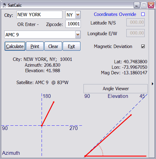
You can either choose to enter a city name with a state abbreviation, or just a zipcode.
-
The software is programmed to take zipcode precedence over city name. This was chosen because often, there are cities that exist with multiple zipcodes (eg. New York, NY). Using the zipcode option is the most accurate way of providing information for the software's calculations.
-
If you do not enter any information into the program, it will use New York, NY (zipcode: 10001); and AMC 9 as the default information when the the Calculate button is clicked.
-
The user interface is intuitive and pretty much self-explanatory. Here is a screenshot of the software.
-
Just a note on the printing functionality... It's very basic. You will get a 'print preview' window, that should show you what your info will look like, and from there you may pursue further printing activities. I always like to preview before I print so I get an eyeball on things, and this is just the way I've done it. Would not be difficult at all to replace with immediate print functionality. And of couse, the sourcecode is available.
-
If you can't get the program to work, and it's saying that you need a particular file or dependency, it might be possible that you do not have .NET Framework 1.1 installed.
-
This program requires that the .NET Framework 1.1 be installed on the target system to work at all. This is not a case of 'might work without it', this program absolutely requires .NET 1.1 as it is compiled with the CLR (Common Language Runtime) compiler.
-
If you have other questions, please feel free to e-mail. HumanBlade@users.sourceforge.net
-
And please remember, this program is offered for free; and per the bundled license, offers no guarantee whatsoever as to the correct functioning or safety of running SatCalc. Please review the GPL for further information as to your rights involving this program.
-
Any thoughts on design or functionality? Any feature you wish my program had? I'm always looking for ways to improve my little works, so please drop me a line if you've any ideas.
Version 1.2
- The program has been updated to allow user-persistence. It will now load the last location and satellite that the user used. Also, sligthly tweaked interface. Better exception messages, less exceptions :) No more fade-in/fade-out. Instead, pretty, informative splash-screen that should cover loading time a bit.
Version 1.1
-
Just a note that now (SatCalc 1.1+) actually corrects for magnetic deviation. Yes this was a bug :)
-
Also, I've added an Expert Mode so that latitude and longitude coordinates can be entered in directly. As of now, this does not add much, if any, functionality to the program in and of itself. I hope that when I'm able to put other (read:non-USA) birds in my lists that this may serve to function for those cities and countries abroad. Though I will most probably add coordinate listings for highly populated cities. Not quite sure yet; any suggestions?
-
Satellite information is updatable.
- This has been accomplished through remote files updated by hand, by me. (*Note: U.S. satellites only, as always)

![[XML]](img/xml.gif)