![[XML]](img/xml.gif)
SatCalc Updated & Released
The program has moved out of private beta testing and has been released for general usage. I'm very excited to offer this software as a free, open source solution for technicians in the satellite communications field. The program is licensed by way of the GPL. I hope to harbour goodwill, appreciation, feedback, and continued development within this project.
The update is merely to reflect the changes inherent in the switchover to the SourceForge servers. The automatic updates of the older version shall remain in effect for a bit longer until I begin to phase them out. I encourage everybody who has any older versions to please update to the latest as SourceForge will now be the de facto 'go-to' site for all future SatCalc releases.
What is SatCalc?
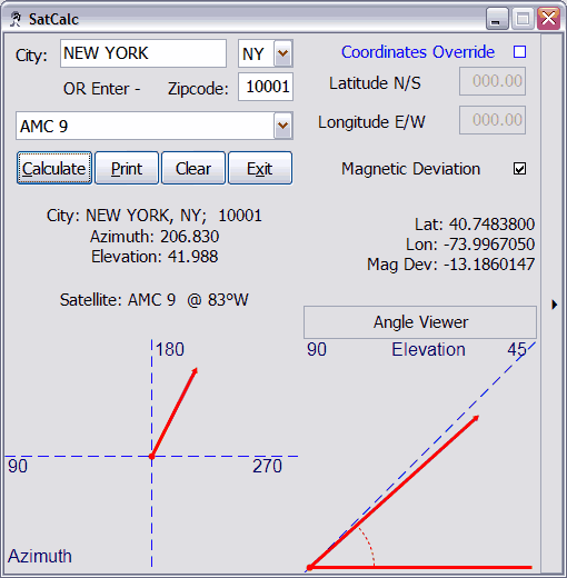
SatCalc is what's called a look angle calculator. It is utilized by satellite communications professionals in order to exactly pinpoint the position of a geo-stationary satellite relevant to an earth-station. What this means is that, given a particular location on earth, it should give you azimuth and elevation coordinates for the desired satellite in the sky. This particular version currently works (as it was originally intended) for American locations and their available satellites.
No, I don't believe I am a bigoted american. The software was originally developed for my own private use as a technician. It has been tested by me, and other users; and used by myself and other satellite technicians. I decided to release it for my own selfish desire of feedback, and my love for the open source, and free software phillosophy. No altruism, as I do enjoy the comments and feedback of all the users. As stated before, I hope to extend this software in the future to cover a more global view.
The code and calculations will always stay the same, as these are standard equations of trigonometric basis. The functionality has to be extended by location-based input. I've yet to decide the best way to do this. I'm still researching other open source projects to see the extent of these possibilities. With the explosion in GPS technology, this may soon come to fruition. The problem is data, people. How can I provide a full fledged international version of my software without have coordinates for every possible location?
This software uses a database from the collaborative efforts of the USGS and the USPS. This allows a coordinate/city database that serves very conveniently for the needs of the software.